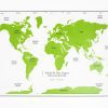
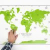
World At Your Fingers features a large tactile reference map showing the major oceans and land masses of the Earth using high-contrast raised surfaces, braille and print labels, and textured lines and areas. It also shows major mountain ranges, rivers, and lines of longitude and latitude.
Age Range: 8 and Up
Four additional maps in this set include:
Embossed map of the world
Raised-line world map
Sinusoidal map (orange peel)
Map of Antarctica
A large print guidebook is included with suggested uses, general principles of map instruction, extension activities, and additional resources.